
2022-12-14
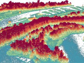
We processed the AHN3 LiDAR point cloud (∼16 TB uncompressed data volume) into 10 m resolution raster layers of ecosystem structure at a national extent. The raster layers (available as GeoTIFF files) capture 25 LiDAR metrics of vegetation structure, including ecosystem height (e.g. 95th percentiles of normalized z), ecosystem cover (e.g. pulse penetration ratio, canopy cover, and density of vegetation points within defined height layers), and ecosystem structural complexity (e.g. skewness and variability of vertical vegetation point distribution). See our data publication. The raster layers are available from Zenodo.
BIOMAC contact
Dr. W.D. (Daniel) Kissling
Email: wdkissling@gmail.com
Phone: +31 (0)20 525 8423
Postal address
Institute for Biodiversity and Ecosystem Dynamics (IBED)
P.O. Box 94248, 1090 GE Amsterdam
The Netherlands