BIOMAC participants: Harry Seijmonsbergen, Joris Timmermans and W. Daniel Kissling
Satellite remote sensing provides key information on biodiversity, ecosystems and Land Use Land Cover (LULC) around the world. The radiation observed from satellites, e.g. through multi-temporal, very high resolution, and hyperspectral satellite sensors, directly links to the distribution of ecosystems (e.g. forest cover), LULC (e.g. ESA CCI Land Cover) and to the functional traits of plants (e.g. biomass, leaf area index, and chlorophyll content). To extract the best information from the wide variety of optical, thermal and microwave satellite sensors in orbit, present-day remote sensing uses a variety of state-of-the-art techniques, such as radiative transfer models, model emulators, neural networks, and data-assimilation. Information obtained from these techniques can then be used to map biodiversity and ecosystems and to investigate the impact of natural and anthropogenic drivers (e.g. LULC) on biodiversity around the world.
Our current research is focused on:
Identifying and quantifying how satellite remote sensing can contribute to monitoring biodiversity change, e.g. in the context of biodiversity indicators and Essential Biodiversity Variables (EBVs)
Applying, testing and developing new image analysis techniques, such as neural networks and data assimilation, to process and combine different satellite observations
Mapping of plant functional traits and vegetation characteristics across a variety of environments and habitats
Quantifying the impact of natural and man-induced pressures on ecosystem functioning and services.
Examples are the analysis and construction of workflows for essential biodiversity variables, the development of indicators for managing protected areas, the characterisation of (the impact of) alien invasive species, and quantification of the vulnerability of communities and ecosystems to natural and man-induced hazards.
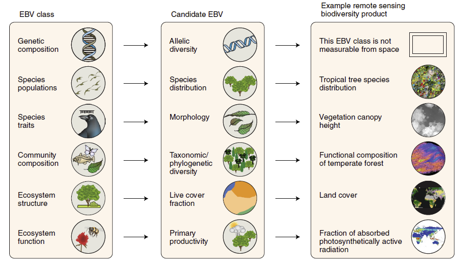 Figure: Linking the framework of essential biodiversity variables (EBVs) to available satellite remote sensing products (from Skidmore et al. 2021, Nature Ecology & Evolution).
BIOMAC contact
Dr. W.D. (Daniel) Kissling
Email: wdkissling@gmail.com
Phone: +31 (0)20 525 8423
Postal address
Institute for Biodiversity and Ecosystem Dynamics (IBED)
P.O. Box 94248, 1090 GE Amsterdam
The Netherlands