2019-04-13
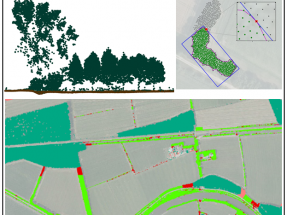
The first paper in Diversity and Distributions is a review article about the current use of LiDAR‐derived vegetation metrics in diversity and distribution research of birds. It shows which LiDAR metrics are currently used and develops a conceptual framework for grouping all metric names into classes defined by vegetation part (total vegetation, single trees, canopy, understorey, and other single layers as well as multi‐layer) and structural type (cover, height, horizontal variability and vertical variability). The second LiDAR paper in Remote Sensing shows how we can map linear vegetation elements (e.g. hedges, tree lines) in agricultural landscapes using LiDAR point clouds only. The developed methodology is a promising step towards mapping linear vegetation structures across large areas, e.g. at the scale of a country.
BIOMAC contact
Dr. W.D. (Daniel) Kissling
Email: wdkissling@gmail.com
Phone: +31 (0)20 525 8423
Postal address
Institute for Biodiversity and Ecosystem Dynamics (IBED)
P.O. Box 94248, 1090 GE Amsterdam
The Netherlands